The Ridgeway #7: Liddington Hill to Avebury

Today's walk was much more a feat of endurance compared to yesterday's ebullient stroll. I had barely slept, and around 5am, as it started to get light, and the rain had finally stopped, I decided I might as well just get up and continue walking.

It was a foggy start to the day, and the wet grass on the greener parts of the path resulted in my feet getting surprisingly soaked. They were already sore from yesterday's walk, and that, combined with the water and the fact I was wearing the cheaper of the two pairs of walking socks I had brought with me meant it wasn't long before I started to feel blisters forming. It probably didn't help either that I was sleep deprived and therefore stumbling along a bit. I made a couple of stops along the way, to apply blister plasters, and later on to change socks. I'm sure these measures helped a bit, but it was still a fairly painful walk today. It was correspondingly a very slow one - today I walked a little over 14 miles, but it took nearly 7 hours - accounting for the ascents etc the OS Maps site calculated it should have been just over 5 hours.


Still, I did my best to try and ignore the discomfort and enjoy the route. A little over an hour into the morning's walk a section of the path was lined with what I think are rosebay willowherbs, and it looked quite pretty.


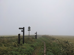
The fog was starting to lift by around 6:30, but I managed to capture a couple more slightly misty scenes before it vanished completely.

At the southern edge of the near complete circumnavigation of Ogbourne St. George the Ridgeway takes here, it crosses the Chiseldon and Marlborough Railway Path - going through the remains of a dismantled railway bridge.
Perhaps it was partly down to being tired, sore and a bit cranky, but I have to admit to beginning to question the route of the Ridgeway National Trail at this point. The original, ancient, Ridgeway logically follows in a fairly straight line from Liddington Hill to Barbury Hill. This section of the route is a road today, and although I hadn't particularly enjoyed the walk along the road yesterday when I crossed over the M4, had I just perserved it looks like it eventually turns into a quiet country lane on Street View. When I'd walked from Lewknor to Goring I'd opted to follow the original route of the Ridgeway along country lanes rather than the modern national trail, and have no regrets. So in hindsight I wish I had done the same for today's walk. I really don't understand why the modern trail has to dip so far south, and do more than a semi circle to bypass Ogbourne St. George here - I assume it's just a question of land ownership, and where established public footpaths already existed before the trail was established in the 1970s. It's not as though this detour takes in any breathtaking scenery.

On the roughly three mile U shape curve around Ogbourne St. George it's pretty frustrating how there are regular signs pointing to the aforementioned village, continuously stating that it's only half a mile or a mile away. This was not good for morale - it felt like I wasn't making any progress! None of these signs ever told me I was getting any closer to Avebury.


When the trail finally broke free of the orbit of Ogbourne St. Bloody George, it was to head up Coombe Down, which was a pleasing change of scenery, and the landscape really opened up again.

This then led on to Smeathe's Ridge, and I decided to rest a while here, both to have a second breakfast (having so far only eaten a biscuit), and to see what could be done about my feet. I contemplated getting my stove out and cooking a "proper" meal, but in the end just ate some vegan jerky, and that seem to buck me up a bit. I also changed into some dry socks, which probably helped too. I stayed here nearly half an hour in the end. I suppose I had been walking for nearly three hours prior to this rest, so it wasn't entirely unwarranted.


Onwards, to Barbury Castle, where the modern trail met up with the original route of the Ridgeway once again. This was the half way point of today's walk - about 7 miles done, about 7 to go. I'm still a bit confused how it had taken me about four hours to get this far - even if you take that half hour rest on Smeathe's Ridge into account, that's still an average of only 2 miles an hour - I must have been really limping along!

I managed to pick up the pace at least slightly after Barbury Hill, perhaps with the knowledge that I was close to Hackpen Hill, and from there on I'd be on familiar ground - that having been the starting point for the walk we did to Avebury for the summer solstice last year.

I got to Hackpen Hill around 10 o' clock. I didn't linger at all - having seen the white horse last year on a day with better weather than today. Instead I attempted to keep up with my renewed burst of energy (which probably only just about equalled normal walking speed).


Eventually though, temptation lay before me, in the shape of a bench, somewhere around Berwick Basset Down. I had been longing to sit on something other than the ground all morning, and couldn't resist. I seemed to be aching all over by this point, so the hard bench offered little comfort, as conveyed by the pained expression in the above photo.

On last year's walk from Hackpen Hill to Avebury, I had chosen a "short cut", down Monkton Down. We had attempted to follow a footpath which appears to go a much more direct route to Avebury rather than just following the Ridgeway followed by the Wessex Ridgeway (also referred to as "Herepath or Green Street" on the OS Map), which is more of a right angle / dogleg. Last year we'd then fallen foul of the fact that the footpath on this supposed short cut disappears through a large field of wheat. Apparently I hadn't learned from that experience, as I attempted the same thing again today. In my defence, it appeared from a distance that the wheat field had been cut, and from the top of the hill the line of where the footpath should be appeared to be visible.

However once I got up close, the footpath again seemed to disappear into a mass of this stuff. There were no signposts or stiles to give any hints on where to start or end the apparent diagonal crossing of these two wheat fields, if you believe the route of the footpath as shown on the OS Map. So instead I followed the farm track, making it much more of a zig zag sort of route than a nice straight line as it appears on the map, and I suspect I might just as well have followed the Ridgeway / Wessex Ridgeway route. Another couple of wrong turns further along this "short cut" rather compounded that notion.

Eventually though, I reached Avebury, and the very welcome sight of the Red Lion, just after midday. Under normal circumstances I might have gone and paid my respects to the stones first, but today I was tired, hungry, thirsty, in pain, and generally a bit fed up. Consequently my immediate needs were far more physical than spiritual. After a couple of pints of bitter shandy, a pint of water, and some lunch (I felt compelled after the dehydrated meals to eat something fresh and green, so ordered a salad) I was at least partly revived and ready to feel something other than just relief that my walk had come to an end.
By coincidence I had started at midday the previous day, so I had done more or less 30 miles in a 24 hour period. Of course that wasn't technically one day, but that said I hadn't really slept in the middle either. Temporal quibbles aside, I think that must be the furthest I've ever walked in 24 hours. My phone tells me I did 65,000 steps.
Now, those of you familiar with the Ridgeway will note that the actual end of the national trail is Overton Hill, about a mile and a half south east of Avebury. Indeed it had been my lofty intention originally to walk all the way there; I had then imagined a casual saunter around the antiquities in that area - The Sanctuary, West Kennet Long Barrow, Silbury Hill, before making a triumphant final approach to Avebury via the stone avenue to the south of the circle. You may not be surprised to read though that given the toll the walk had taken, I had made an executive decision to just cut it short, and end at Avebury. I could look forward to visiting all those sites another time, when I wasn't experiencing pain with every footstep.
Moreover, surely Avebury would have been the ultimate destination of the ancient Ridgeway?


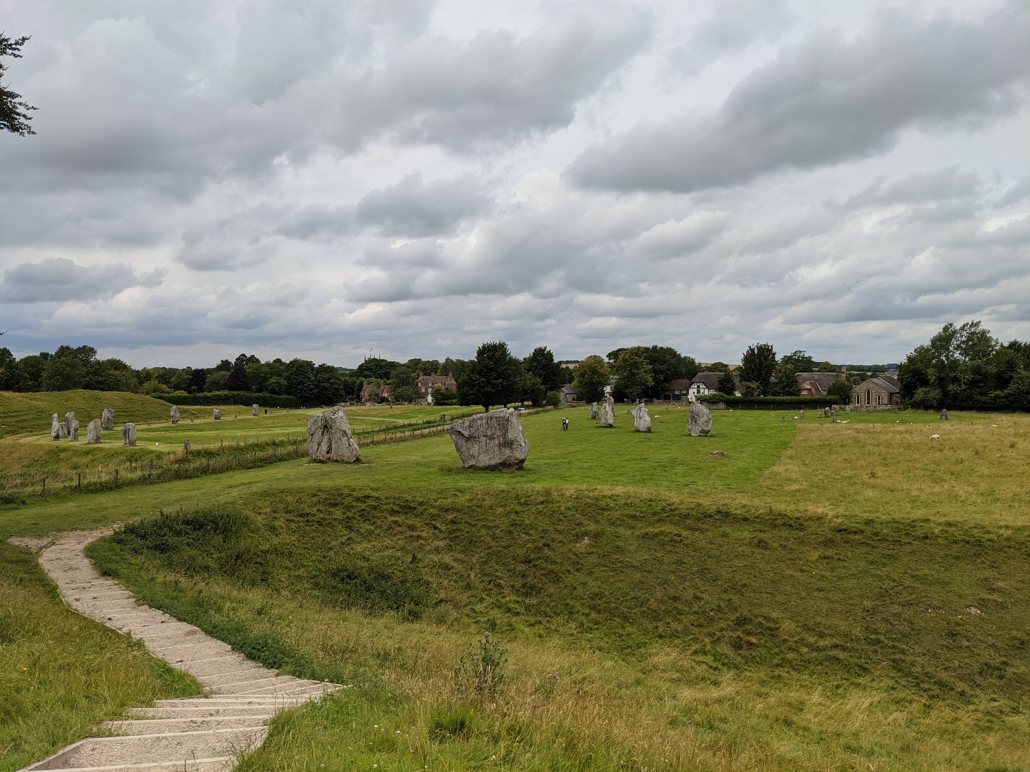
After lunch, I had about half an hour before the bus to Swindon left, so used that time to pay my respects to the stones. The weather was rather glum today, and the stones seemed somehow muted compared to how they'd been at the summer solstice last year, or even the winter solstice. Perhaps I was projecting my state of exhaustion a bit.

Regardless though, I was happy to have made it here. On foot. Yes it had mostly been in daytrip sized sections, and yes that meant getting trains to and fro for each of those chunks, and yes I'd cut a couple of corners here and there, but I'd still walked a distance roughly equivalent to getting to Avebury from home in London. There had definitely been the sense of a pilgrimage of sorts to it.
I had wanted it to be a journey that would transport me from modernity into antiquity. An escape from the ennui of modern life to the mysticism and atavism of our forebearers.
Ironic then, that by the end of it I found myself craving nothing more than a hot shower and a comfortable bed!
Well done, that man!
ReplyDelete